BabelStone Blog
Wednesday, 10 April 2013
A Fragment of Tangut Geography
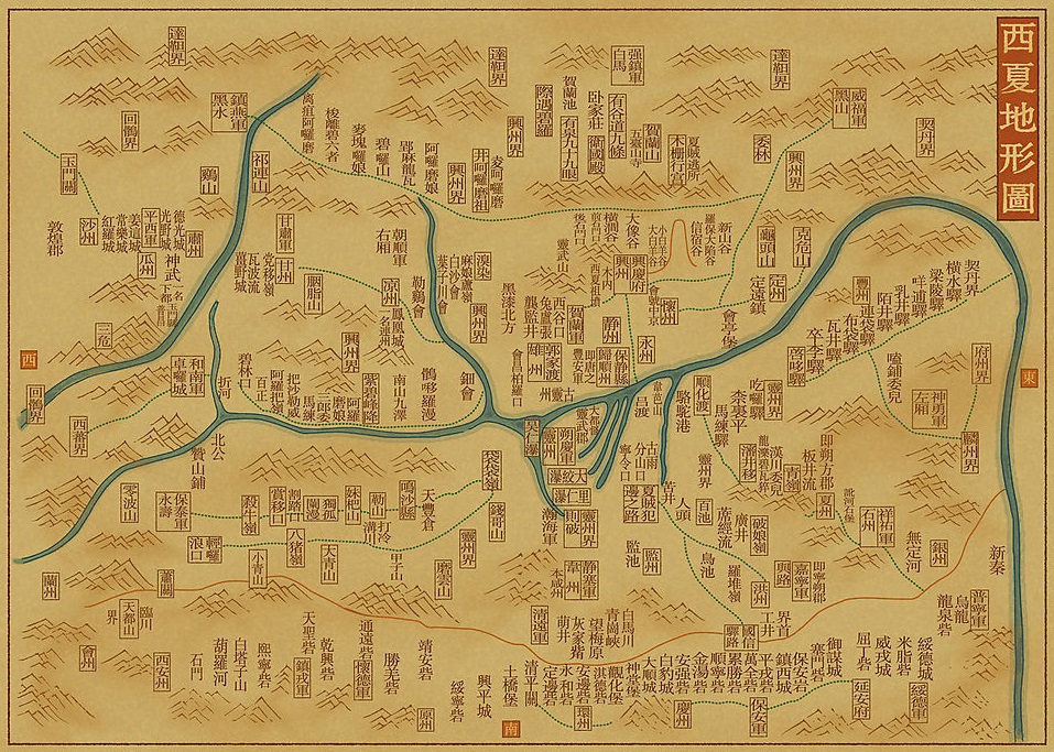
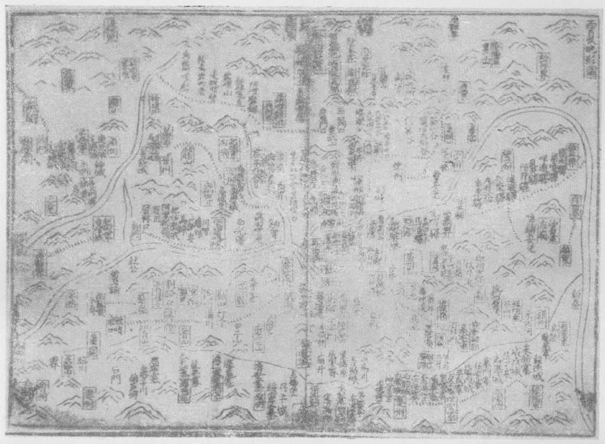
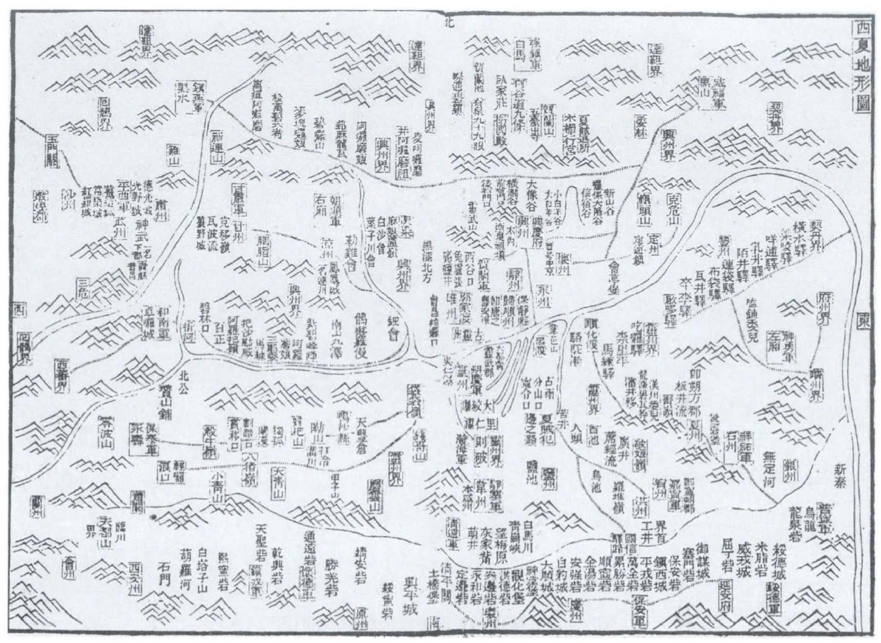
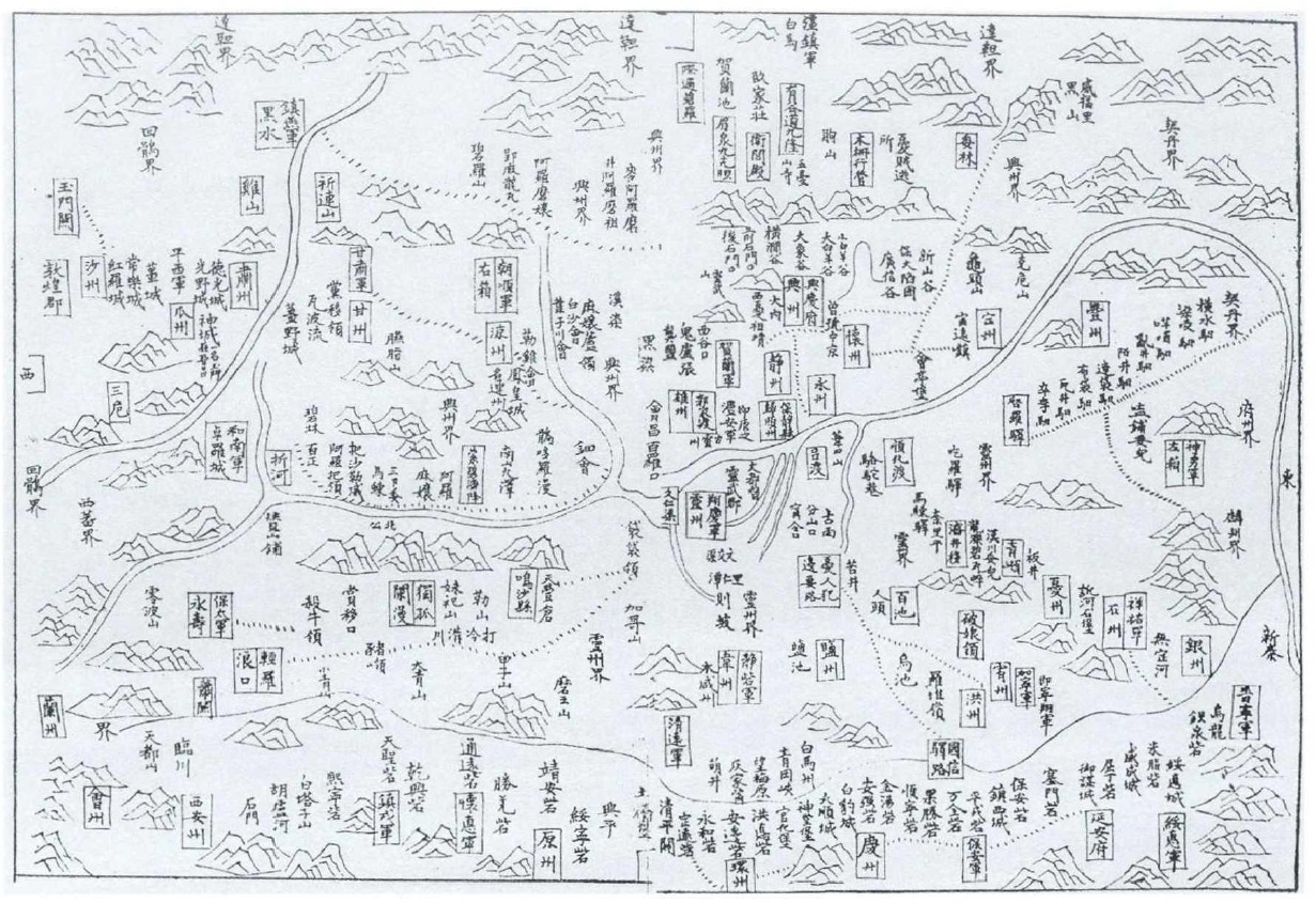
Something I have always wanted to see is an original 12th or 13th century map of the Western Xia territory with place names written in the Tangut script. Unfortunately, as far as I know, no such map exists any longer. However, there is a Chinese map of the Western Xia territory entitled the Western Xia Topographic Map (西夏地形圖 Xīxià dìxíng tú) that probably dates back to the late Northern Song (circa 1108), although extant editions were printed between 1608 and 1895 :
- Map included in the Collected Works of Fàn Wénzhèng in a Ming Wanli 36 (1608) edition of The Collections of Two Famous Song Dynasty Ministers (宋兩名相集), held at the National Library of China in Beijing
- Map included in a Ming Wanli 37 (1609) edition of the Collected Works of Fàn Wénzhèng (重校范文正公集), held at Peking University Library
- Map included in the 1895 edition of the Chronological History of the Western Xia 西夏紀事本末 compiled by Zhāng Jiàn 張鑒 (1768–1850)
- Map collected from China in the late 19th century by Konstantin Andreianovich Skachkov (1821–1883), held at the Russian State Library in Moscow
Modern Redrawing of Zhāng Jiàn's 1895 version of the Western Xia Topographic Map (unknown creator)
Version of the Western Xia Topographic Map in the 1608 edition of The Collections of Two Famous Song Dynasty Ministers (宋兩名相集) held at the National Library of China
Source: Huáng Chéngzhāng and Wāng Qiánjìn (1992)
Version of the Western Xia Topographic Map in the 1895 edition of the Chronological History of the Western Xia (西夏紀事本末)
Source: Zhāng Duōyǒng and Lǐ Bìngchéng (2018) Fig. 1
Version of the Western Xia Topographic Map held at the Russian State Library in Moscow
Source: Zhāng Duōyǒng and Lǐ Bìngchéng (2018) Fig. 2
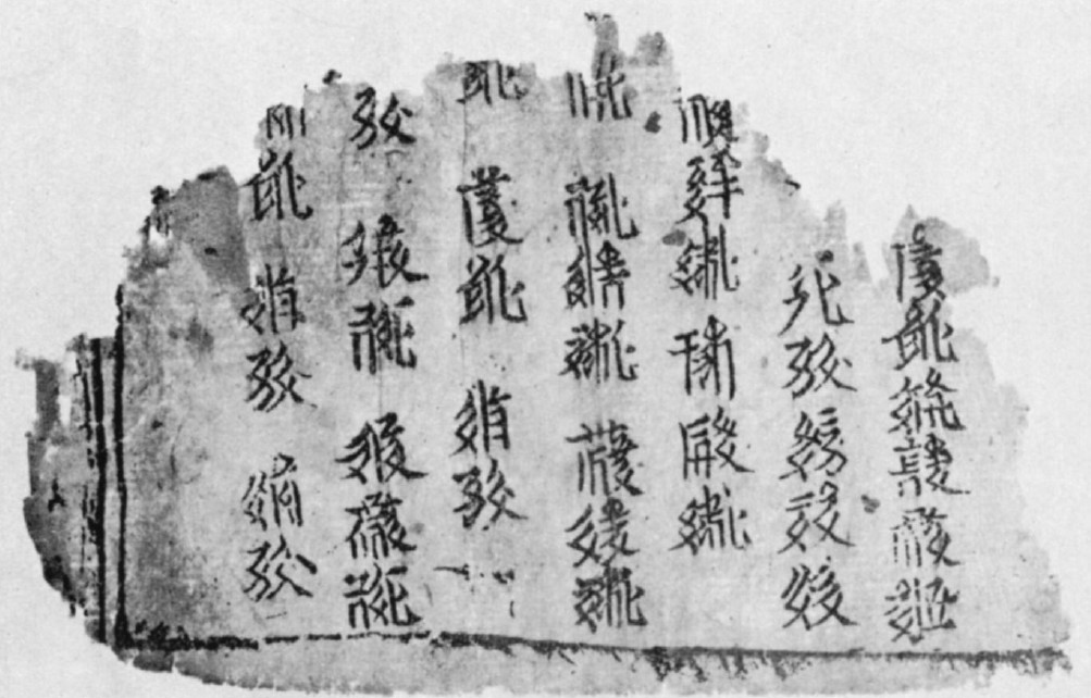
As far as I know, there are no surviving examples of Tangut geographic or topographic works, but parts of the Western Xia Law Codes enumerate administrative divisions and list various place names. 150 fragments of the Western Xia law codes as established during the Celestial Prosperity era (1149–1169), collected from Kharakhoto by P. K. Kozlov in 1909, have been compiled by E. I. Kychanov and published as The Revised and Newly Endorsed Code for the Designation of Reign ‘Celestial Prosperity’ (1149-69) in 1989. Unfortunately, I have not had the opportunity to see this book, but yesterday I came across a fragment of a page from a printed edition of the Western Xia law codes collected by Aurel Stein from Kharakhoto in Eric Grinstead's 1961 discussion of "Tangut Fragments in the British Museum" :
Fragment of an edition of the Western Xia Law Codes held at the British Library (Or. 12380/2249)
This fragment consists of lists of Western Xia place names. I have transliterated and translated these in the table below :
| Line | Tangut Character |
Reconstructed Reading (Li Fanwen 2008) |
Meaning | Translation |
|---|---|---|---|---|
| 1.1 | 𗑛 | *zjɨr | "south" 南 | Southern Court 南院 (an administrative department) |
| 1.2 | 𘍞 | *iọ | "court" 院 | |
| 1.3 | 𗦖 | *mjijr | "palace" 宮 | Mobile Palace 行宮 |
| 1.4 | 𘛂 | *bji̱j | "to travel" 行 | |
| 1.5 | 𗱽 | *dzjɨ | "to provide" | "three offices" 三司 = "State Finance Commission" |
| 1.6 | 𘏬 | *ka̱r | "steelyard" (a balance) | |
| 2.1 | 𗉺 | *śia | Transcribes Chinese sha 沙 "sand" | Shazhou 沙州 (modern Dunhuang in Gansu) |
| 2.2 | 𗉔 | *tśjiw | Transcribes Chinese zhou 州 "prefecture" | |
| 2.3 | 𘊐 | *kjij | Transcribes Chinese jing 敬, 經, jin 近, etc. | Fiscal Commission 經治司 |
| 2.4 | 𗶃 | *tśji | Transcribes Chinese zhi 至, 治, 志, etc. | |
| 2.5 | 𗬐 | *sə | Transcribes Chinese shi 氏, si 司, 斯, etc. | |
| 3.1 | 𗙓 | *da | Transcribes Chinese lin 臨, 林, etc. | Linhe County 臨河縣 (modern Bayannur in Inner Mongolia) |
| 3.2 | 𘔘 | *xụ̃ | Transcribes Chinese hong 紅 "red", 洪, 弘, he 和, 河 etc. | |
| 3.3 | 𗾩 | *xjwã | Transcribes Chinese xian 縣 "county" | |
| 3.4 | 𗌷 | *po | Transcribes Chinese bao 堡 "fort", 保, 包, etc. | Baojing County 保靜縣 (in the vicinity of modern Wanghong 望洪 in Yongning County in Ningxia) |
| 3.5 | 𗂎 | *tshjɨj | "purple"; also transcribes Chinese qian 倩, qing 青, jing 靜, etc. | |
| 3.6 | 𗾩 | *xjwã | Transcribes Chinese xian 縣 "county" | |
| 4.1 | 𗅏 | *ljạ | to pierce (also used in place names) | ? |
| 4.2 | 𗍾 | *wjij | Transcribes Chinese wen 温, yong 永, ying 穎, etc. | Yongchang County 永昌縣 (modern Yongchang County in Gansu) |
| 4.3 | 𘊇 | *śjow | "to guard"; also transcribes Chinese shang 尚, chang 昌, etc. | |
| 4.4 | 𗾩 | *xjwã | Transcribes Chinese xian 縣 "county" | |
| 4.5 | 𗝖 | *khej | "luxuriant"; also transcribes Chinese kai 開, 凱, etc. | Kaibian County 開邊縣 (in the vicinity of modern Zhenyuan County in Gansu) |
| 4.6 | 𗦿 | *pjɨj | Transcribes Chinese bian邊 "border" | |
| 4.7 | 𗾩 | *xjwã | Transcribes Chinese xian 縣 "county" | |
| 5.1 | 𘍞 | *iọ | "court" 院 | ... Court ...院 |
| 5.2 | 𗑛 | *zjɨr | "south" 南 | Southern Court 南院 (an administrative department) |
| 5.3 | 𘍞 | *iọ | "court" 院 | |
| 5.4 | 𗤊 | *su | "to plot"; also transcribes Chinese su 肅 | Suzhou 肅州 (modern Jiuquan in Gansu) |
| 5.5 | 𗉔 | *tśjiw | Transcribes Chinese zhou 州 "prefecture" | |
| 6.1 | 𗉔 | *tśjiw | Transcribes Chinese zhou 州 "prefecture" | ...zhou ...州 |
| 6.2 | 𗋽 | *zjɨ̱r | "water" 水 | Black Water 黑水. The Ejin River in Gansu and Inner Mongolia, perhaps referring specifically to the Tangut fortress city of Kharakhoto (黑水城), known to Marco Polo as Etzina. |
| 6.3 | 𗰞 | *nja̱ | "black, dark" 黑 | |
| 6.4 | 𗼚 | *•ow | Character used in Tangut surnames, of uncertain meaning here | Black Mountains (the Wolf Mountains or the western part of the Yin Mountains 陰山 in Inner Mongolia). Transcribed in Chinese as 午腊蒻 wǔlàruò in the History of the Song Dynasty 宋史 vol. 485 (see Nie Hongyin 2008). |
| 6.5 | 𗲞 | *rar | "hill, mountain" 山 | |
| 6.6 | 𗰞 | *nja̱ | "black, dark" 黑 | |
| 7.1 | 𗂰 | *lji | "west" 西 | Western Court 西院 (an administrative department) |
| 7.2 | 𘍞 | *iọ | "court" 院 | |
| 7.3 | 𗤊 | *su | "to plot"; also transcribes Chinese su 肅 | Suzhou 肅州 (modern Jiuquan in Gansu) |
| 7.4 | 𗉔 | *tśjiw | Transcribes Chinese zhou 州 "prefecture" | |
| 7.5 | 𗽝 | *kiwa | Transcribes Chinese gua 瓜, 寡, etc. | Guazhou 瓜州 (modern Guazhou County in Gansu) |
| 7.6 | 𗉔 | *tśjiw | Transcribes Chinese zhou 州 "prefecture" |
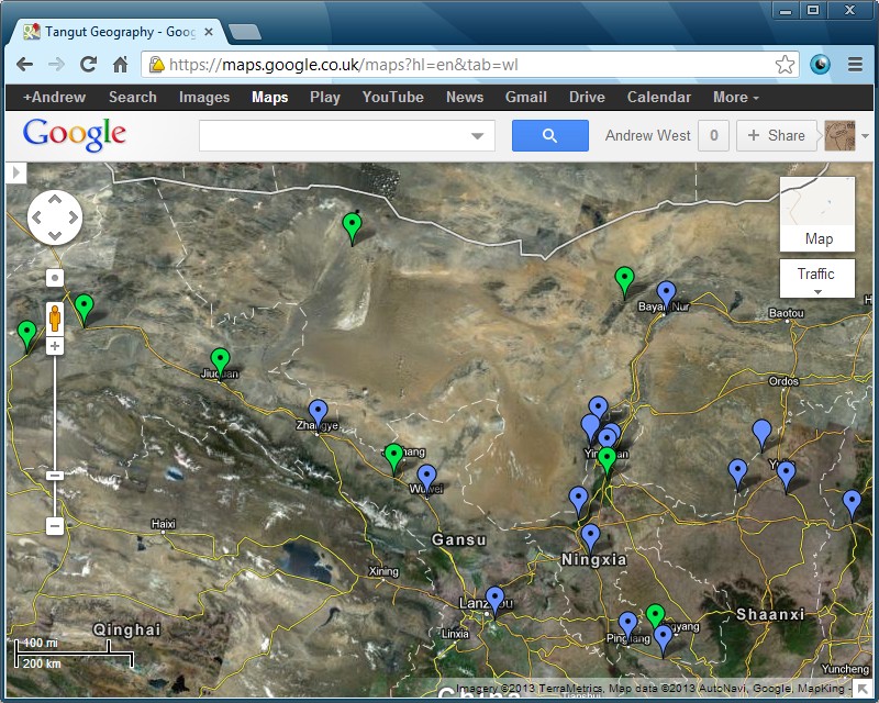
Having translated the above fragment, I thought it would be a fun idea to plot the place names mentioned in it on Google Maps, with the names given in Tangut script. This I have done on the map below, with additional place names taken from other sources. Click on a tag to see the name of the place in Tangut characters.
Google Maps map showing Western Xia locations with place names in Tangut
Note 1. Some Tangut place names are written with different characters in different sources, and where this is the case one spelling has been arbitrarily chosen.
Note 2. Tags without a dot in the middle indicate that the exact location of the place is uncertain or unknown.
Index of Tangut Place Names
𗴂𗹭𗂧𘜶𗼻𗦻
Superior Prefectures
| Tangut Name | Chinese Name | Modern Location | |
|---|---|---|---|
| 𗤛𗼵𗥑 | *tśhjow xjow xu | Zhōngxīng Superior Prefecture 中興府 |
Yinchuan 銀川, Ningxia |
Prefectures
| Tangut Name | Chinese Name | Modern Location | |
|---|---|---|---|
| 𗇊𗉔 | *thjij tśjiw | Dìngzhōu 定州 |
Pingluo County 平羅縣, Ningxia |
| 𘑫𗉔 | *kã tśjiw | Gānzhōu 甘州 |
Zhangye 張掖, Gansu |
| 𗽝𗉔 | *kiwa tśjiw | Guāzhōu 瓜州 |
Guazhou County 瓜州縣, Gansu |
| 𗘒𗉔 | *kwej tśjiw | Huìzhōu 會州 |
Jingyuan County 靖遠縣, Gansu |
| 𘊐𗉔 | *kjij tśjiw | Jīngzhōu 涇州 |
Jingchuan County 涇川縣, Gansu |
| 𗃛𗉔 | *ljow tśjiw | Liángzhōu 涼州 |
Wuwei 武威, Gansu |
| 𗉺𗉔 | *śia tśjiw | Shāzhōu 沙州 |
Dunhuang 敦煌, Gansu |
| 𗫍𗉔 | *śji tśjiw | Shízhōu 石州 |
Lüliang 呂梁, Shanxi |
| 𗤊𗉔 | *su tśjiw | Sùzhōu 肅州 |
Jiuquan 酒泉, Gansu |
| 𗫐𗉔 | *su tśjiw | ||
| 𗦭𗉔 | *zu tśjiw | ||
| 𗉢𗉔 | *śjwa tśjiw | Suīzhōu 綏州 |
Suide County 綏德縣, Shaanxi |
| 𘖅𗉔 | *we tśjiw | Wéizhōu 韋州 |
Tongxin County 同心縣, Ningxia |
| 𘒂𗉔 | *xia tśjiw | Xiàzhōu 夏州 |
North of Jingbian County 靖邊縣, Shaanxi |
| 𗼵𗉔 | *xjow tśjiw | Xīngzhōu 興州 |
Yinchuan 銀川, Ningxia |
| 𗂠𗉔 | *xjow tśjiw | Xióngzhōu 雄州 |
Zhongning County 中寧縣, Ningxia |
| 𗷲𗉔 | *gjĩ tśjiw | Yínzhōu 銀州 |
Northwest of Mizhi County 米脂縣, Shaanxi |
| 𘝰𗉔 | *gjĩ tśjiw | ||
| 𗍃𗉔 | *·jiw tśjiw | Yòuzhōu 宥州 |
Northeast of Yulin 榆林, Shaanxi |
| 𗕸𗼵𗉔 | *tśhjow xjow tśjiw | Zhōngxīngzhōu 中興州 |
Yinchuan 銀川, Ningxia |
Counties
| Tangut Name | Chinese Name | Modern Location | |
|---|---|---|---|
| 𗌷𗂎𗾩 | *po tshjɨj xjwã | Bǎojìng County 保靜縣 |
Vicinity of Wanghong 望洪 in Yongning County 永寧縣, Ningxia |
| 𗇊𗤩𗾩 | *thjij ɣjwã xjwã | Dìngyuǎn County 定遠縣 |
Yuzhong County 榆中縣, Gansu |
| 𗥑𗫲𗾩 | *xu khjij xjwã | Fùqīng County 富清縣 |
Xinhure Sumu, Urad Middle Banner, Inner Mongolia. Site of the Black Mountain Fortress (Mongolian Uraqai, Chinese 兀剌海城). |
| 𘌴𗤩𗾩 | *xiwəj ɣjwã xjwã | Huáiyuǎn County 懷遠縣 |
Helan County 賀蘭縣, Ningxia |
| 𗝖𗦿𗾩 | *khej pjɨj xjwã | Kāibiān County 開邊縣 |
Vicinity of Zhenyuan County 鎮原縣, Gansu |
| 𗙓𘔘𗾩 | *ljwĩ xụ̃ xjwã | Línhé County 臨河縣 |
Bayannur, Inner Mongolia |
| 𗦮𗃛𗾩 | *tshjịj ljow xjwã | Píngliáng County 平涼縣 |
Pingliang 平涼, Gansu |
| 𗍾𘊇𗾩 | *wjij śjow xjwã | Yǒngchāng County 永昌縣 |
Yongchang County 永昌縣, Gansu |
Forts
| Tangut Name | Chinese Name | Modern Location | |
|---|---|---|---|
| 𗐹𗤩𗌷 | *·ã ɣjwã po | Ānyuán Fort 安原堡 |
|
| 𗍁𗽤𗌷 | *we tśhiej po | Chéngzhài Fort 城寨堡 |
|
| 𗦃𗇊𗌷 | *xwej thjij po | Huídìng Fort 回定堡 |
|
| 𗘬𗷌𗌷 | *sjwa te po | Xuāndé Fort 宣德堡 |
|
Mountains
| Tangut Name | Chinese Name | Modern Location | |
|---|---|---|---|
| 𗼚𗲞𗰞 | *·ow rar nja̱ | Black Mountains 黑山 |
The Wolf Mountains 狼山 or the western part of the Yin Mountains 陰山 in Inner Mongolia. May refer specifically to the Heishan Weifu Military Command (黑山威福軍司) garrisoned at the Black Mountain Fortress (Mongolian Uraqai, Chinese 兀剌海城) at Fùqīng County 富清縣. |
| 𗲡𗝢𘑗 | *xẽ lã ŋər | Helan Mountains 賀蘭山 |
The Helan Mountains 賀蘭山. |
| 𗉨𗔕𘑗 | *tśjɨ̱r njir ŋər | Wutai Mountain 五臺山 |
Perhaps the site of the Baisigou Square Pagoda in the Helan Mountains. Named after the the famous Buddhist mountain Wutaishan in Shanxi. |
Rivers
| Tangut Name | Chinese Name | Modern Location | |
|---|---|---|---|
| 𗋽𗰞 | *zjɨ̱r nja̱ | Black Water 黑水 |
The Ejin River. May refer specifically to the Heishui Zhenyan Military Command (黑水鎮燕軍司) garrisoned at the Black Water Fortress (Mongolian Kharakhoto, Chinese 黑水城). |
Bibliography
- Grinstead, E. D. "Tangut Fragments in the British Museum"; The British Museum Quarterly vol. 24 nos. 3–4 (December 1961): 82–87.
- Huáng Chéngzhāng 黄盛璋 and Wāng Qiánjìn 汪前进. "New ideas about Xi Xia Di Xing Tu, the first and only map of Western Xia regime that has been handed down" 最早一幅西夏地图—《西夏地形图》新探; Studies in the History of Natural Sciences 自然科學史研究 vol. 11 no. 2 (1992): 177–187.
- Kychanov, E. I. The Revised and Newly Endorsed Code for the Designation of Reign ‘Celestial Prosperity’ (1149-69) Изменённый и заново утверждённый кодекс девиза царствования: Небесное процветание (1149-1169). Nauka, 1989.
- Niè Hóngyīn 聂鸿音. "Additional evidence on the Heishan Weifu Junsi" 黑山威福军司补证; Journal of Ningxia Teachers University (Social Science) 宁夏师范学院学报(社会科学) vol. 29 no. 4 (August 2008): 67–69.
- Zhāng Duōyǒng 张多勇 and Lǐ Bìngchéng 李并成. "Xīxià dìxíng tú suǒ huì jiāotōng dàolù de fùyuán yánjiū" 《西夏地形图》所绘交通道路的复原研究; Lìshǐ dìlǐ 历史地理 no. 36 (2018): 247–269.
Last modified: 2022-05-24
If Tangut characters do not display correctly, please download and install the Tangut Yinchuan font.
Index of BabelStone Blog Posts
